Sign up to unlock all our services and 1230 corrected and explained questions.
Question 24-1 : Time and longitudedifference between utc and pacific standard time pst is 7h during summer at noon pst utc time is ? [ Control aircraft ]
19h utc
Question 24-2 : Indicate how an eastbound direction in air navigation is represented ?
90°.
Question 24-3 : Indicate how a westbound direction in air navigation is represented ?
270°.
Question 24-4 : Indicate the airspace s where a pilot can use a small remotely piloted aircraft in basic operations ?
All the uncontrolled airspace.
Question 24-5 : What does the acronym vnc stands for ?
Vfr navigation charts.
Question 24-6 : What does the acronym vta stands for ?
Vfr terminal area charts.
Question 24-7 : Identify the statement that is correct for very high frequency vhf waves ?
They follow a straight trajectory and can only be captured in line of sight.
Question 24-8 : Which of the following statements is correct ?
The meridians are half circles connecting the true poles.
Question 24-9 : Utc is the local mean time ?
For the prime meridian.
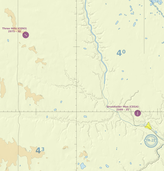
Question 24-10 : The direction and the distance between drumheller aerodrome and three hills aerodrome are 48 ?
Northwest 21 nm.
Question 24-11 : Latitude and longitude are respectively measured for an angular deviation of ?
0° to 90° n or s and from 0° to 180° e or w.
Question 24-12 : The coordinates of the intersection point between the equator and the greenwich meridian are ?
00°n 000°ew.
Question 24-13 : The geographical coordinates of a place are given by reference ?
At the equator and the prime meridian.
Question 24-14 : The waves emitted by low medium and high frequency stations are of two types ?
Surface waves and space waves.
Question 24-15 : Whenever possible notification of conditions requiring the issue of a notam will be distributed in advance ?
Five hours.
Exclusive rights reserved. Reproduction prohibited under penalty of prosecution.
344 Free Training Exam